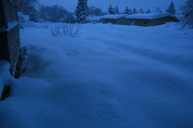
On Saturday we received our mail for the first time in three days. Roads are now open, and about half of the radio stations are back on the air. Helen and I have been shoveling for 3 days straight. We love it but the love is running thin. Here are more pictures!
The official tally for this set of storms is 54.2 inches of snow since Monday, with a water equivalent of 5.27 inches of moisture. This ranks as the second largest snow storm event in our recorded history.
The sun came out today! First time in days and it brightly lit the townhomes across the street from us.
This is 816 W. Cherry Ave. getting some welcome sun
This is the 4X4 pick-up truck in my back yard and its final tally of snow cover
My next door neighbor, Sonny, did not shovel once the whole storm and had 4 feet to clear this morning in one go
No worries though, his daughter helped him!
Thorpe Park near our home
Looking east on West Cherry Avenue
Looking west on West Cherry
One of our favorite restaurants on Milton, Casa Bonita, and the 8 foot high snow banks piled around it
The entrance to the Museum of Northern Arizona was especially beautiful this morning.
Helen and I helped the staff with shoveling snow as the grounds are huge and they needed help to dig out
Helen holding a shovel on a wall that shows the four foot accumulation
Adventure and foreign travel, philosophical and scientific musings, geology and landscapes, photography and earthly explorations.
Saturday, January 23, 2010
Friday, January 22, 2010
More Flagstaff Snow Pictures
We still have no radio stations, no mail delivery (I guess "neither rain nor sleet, now snow" is too old fashioned in these days of e-mail), and no way out of town except north into Utah. It beautiful and fun in a way.
Wayne shoveling snow off of the flat-roof garage. Flat roofs are more likely to cave in if they get too heavy. The rain last night on top of the snow made things very heavy.
A six-foot high fence after shoveling snow
Backyard view
Backyard view
Looking east on Cherry Avenue in front of our home
One of our favorite store's for used books (Bookman's) had its roof collapse last night. The roof is flat. What a shame that all of those books are now ruined with snow and ice falling in. (At least the Science, History, Travel, and Southwest sections of the store did not take the brunt of the collapse).
Newspaper machines on the NAU campus
Parked cars caught in the storm on the NAU campus
Student's cars buried in snow
Flocking on the Christmas trees
trash and recycle bins in front of a southside home
A southside home buried in snow
A gandy dancer appears frozen in front of the freight station in downtown Flagstaff. Thanks to John Grahame for the information on what a gandy dancer is!
Babbit's downtown. Everything is closed - stores, offices, even the movie theaters.
Street scene in downtown Flagstaff
Looking south on LeRoux Street in downtown Flagstaff
This dog found a nice soft cubby hole while waiting for its owner to show up
Over Cedar Hill towards the Safeway store that is closed because of a collapsed roof.
Monster Snowstorm in Flagstaff
Everything is closed except grocery stores. No Flagstaff radio stations are operating. All roads out of town are closed except Highway 89 to the north. More snow on the way and we are almost completely disconnected now. After the asinine Supreme Court decision yesterday - this is paradise. I love it!
This is Cherry Avenue in front of my house. About 4 feet on the ground.
Snow covers my pick-up truck in the back yard.
It's not going anywhere for quite some time.
Need to go back up on the garage roof and shovel some more. The shoveling is not bad. It's good exercise and keeps you warm.
Snow drifts in the backyard.
Standing on a snow bank and looking down on an 8 foot tall shrub.
The fence is six feet tall but I could step over it today
Monday, January 18, 2010
Geology Hike in Sedona
We have received a break in our winter weather (although the break is apparently over this week) and hiking in Sedona is a January past time here in Northern Arizona. I joined a few friends for a geology and archaeology hike not too long ago.
Part way up on a the side of a butte, we obtained a great view of the Permian strata in Sedona. Here you can see an obvious basin floor that is cut into the Hermit Formation. The Hermit is a relatively soft unit in this area and so forms a prominent bench. This is the same surface that the city of Sedona is built upon. The overlying red sandstone belongs to the Schnebly Hill Formation and this in turn is capped by (in ascending order) the Coconino Sandstone, the Toroweap Formation (obvious cliff in the upper right of photo), and the Kaibab Formation.
A fantastic rock monument along the trail within the Schnebly Hill Formation
The leader of our hike knew of this fantastic trackway in the Schnebly Hill Formation. You can easily see toe marks of what most likely was a reptile traveling along a sandy hill. Compression structures from the weight of the animal are also evident in this outcrop.
"Close to the Edge....."
Amazing Sinagua Indian ruins were seen everywhere along this route and their placement in such "edgy" locales was a matter of curiosity to me. The obvious answer is defense but climatic comfort in the stifling summer heat and visual appeal are also possibilities. The black-capped butte in the far distance is Casner Mountain, a 14 million year old (plus or minus) lava flow that caps the Mogollon Rim.
Another view of a "fortress" ruin.
Some of the pictographs were outstanding in this ruin. We also saw a roof beam that had been cut with a stone ax.
Silhouetted by an open door and looking at the red rocks
A large ruin complex. The ruins are built into alcoves that are preferentially carved at geologic contacts, where hard, porous layers overly soft, impervious layers. Before the dissection of the rocks, groundwater affected the cementing agents and allowed for this horizontal weathering pattern.
Marching along in geology paradise
The red bark on this manzanita bush intrigued me.