 December 8 Headline
 Sunrise December 8 on Cherry Ave.
 My car
 My truck
 I did shovel too!
 816 W. Cherry Ave.
 West Cherry Avenue
 Sidewalk
 Blue Sky - but another one is on the way
 December 9 Headline
Adventure and foreign travel, philosophical and scientific musings, geology and landscapes, photography and earthly explorations.
 Zion has a much different mood and feel than what one experiences during more favorable times of the year. The trees have lost their leaves and a gray cast is present withing the narrow confines along the Riverside Trail. Yet beauty abounds in the high rock walls that shelter the gentle Virgin River.
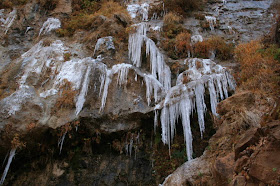
  Icicles drape the canyon walls where seeps freeze on cold winter nights
 Chiseling on a grand scale is evident through the Navajo Sandstone. Everyone asks, "This little river did this?" The answer is yes and no. This river did it but only when it was in a much different and flood-raging mood.
 Outside of the narrows, the canyon widens to the south...
 ...and the layers of strata begin to be revealed. Note that the narrows are formed where the river cuts through the hard walls of Navajo Sandstone (in the upper cliff faces). As the stream cuts downward, softer layers are exposed and thus the canyon widens. These slopes are cut into the Kayenta and Moenave formations.
 Moonset above the West Temple in Zion Canyon
 We exited the park but not the scenery. The little town of Rockville is a joy to visit. Set your watches back 75 years!
 So there are two choices here - this house was built around boulders (Shinarump Conglomerate) that had previously fallen, or the house was built and the boulders later fell around it? The answer is obvious but asking it allows one to understand how to observe the landscape. Do the residents who live here ever think of the day that these boulders fell from the cliff above?
  Virgin, Utah! Elev. 3552.3 feet. Don't forget that 0.3 of a foot! In May 2000, the town council here required that all homes be in possession of a gun (in response to the shootings at Columbine High School). This was highlighted in Michael Moore's 2002 film "Bowling for Columbine."
 A tourist stop west of Virgin. The "Virgin Jail" was empty, apparently, no one qualified. But look at that scenery!
 Most visitors spend their time inside the park boundaries. But we found lots of scenery outside the park to the west. And then it hit me! This should be a newly created, "Portals of Zion National Monument"! What a joy it would be to see these graceful benches and broad terraces protected from home sites.
  The strata are fantastic here. Perhaps the Moenkopi Formation is nowhere else better exposed. Development is happening fast in this land of low birth control. In the foreground is the Kaibab Limestone. The very thin terrace in the middle of the picture is the Virgin Limestone Member of the Moenkopi, and the upper bench is capped by the Shinarump Conglomerate Member of the Chinle Formation.
 Hurricane Mesa, where the US Air Force tested seat ejection technology for fighter jets at the height of the Cold War. A track on top of the Shinarump Conglomerate bench transported dummies and live monkeys in seats that were then ejected at the mesa's edge.
 Farther west is the small town of Toquerville. In the distance, is the upthrown side of the Hurricane fault, with the Kaibab Limestone and overlying basalt flows uplifted thousands of feet along the fault.
 An example of inverted topography along North Creek. Note the basalt flow perched high on the mesa. This flow erupted about one million years ago and filled the valley bottom of North Creek. Since then, it has cut a newer and deeper canyon and the old lava flow is left perched now on a mesa top. Washington County, Utah is a classic locality for this kind of inverted topography.
 Crater Hill, a cinder cone that erupted about 293,000 years ago. It sent a lava flow down Coal Pits wash and then into the Virgin River, where it was dammed for a short while.
 Back inside the park, here is a close-up view of the Kayenta/Navajo contact. Note the springs that issue from the line of contact. Water that is stored in the porous Navajo Sandstone, is deflected outward to the rock wall as is encounters the non-porous beds in the Kayenta. Arches can form in such settings.
 Spectacular sets of cross-beds seen in the Jurassic Navajo Sandstone in Pine Canyon along the Mt. Carmel/Zion Road. This truly was a wind-swept, sandy desert.
 Close-up of other cross-bed sets in Zion.
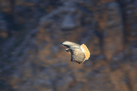
 A red-tailed hawk soars above the future site of "Portals to Zion National Monument"