During election week in the USA, I was serving as a Study Leader for Smithsonian Journey's. This is the travel program for members of the Smithsonian and we were traveling down in the Copper Canyon region of Chihuahua, Mexico. Most of my fellow passengers were happy to be away from the many TV ads, especially those from Florida and Pennsylvania. I don't think there was a chance that even one in our group of 27 travelers was an undecided voter. Nonetheless, we were headed down to warm and sunny Mexico on the private Sierra Madre Express train.
Our group assembled at the historic Arizona Inn in Tucson, built in 1930 when the last big depression hit the world economy. On Halloween morning, we made a stop at the Arizona State Museum and Mission San Xavier del Bac before crossing the border at Nogales and driving to the rail station in Magdalena del Kino.
It was here that Fray Eusebio Kino, the father of the Sonoran and Arizona Spanish missions died and was buried somewhere on the mission grounds. About 30 years ago, workers discovered some bones while digging there. The related artifacts that were included in the burial led some people to believe that this was the burial site of the good Father. His bones are now proudly displayed in a glass case outside the front doors of the mission church. Scenes like this may be a bit macabre for people of English heritage but this is one of the larger tourist attractions in northwest Mexico. Viva Padre Kino!
After traveling on the coastal plain of Sonora, where huge agricultural fields were seen, we entered the Sierra Madre. What a dramatic sight as out little train headed into the vast canyon system of these mountains.
At Temoris, the tracks make a huge loop across the river and then enter a tunnel which itself loops 180 degrees underground. The tracks below go uphill from left to right and this photo was shot as we exited that tunnel traveling right to left.
Look at the size of these boulders within the canyon and along the train tracks. Is it any wonder how these deep canyons are carved? Not really - it is the unusually large floods that have rolled boulders of this size and they physically pound the bedrock and chip away at it through time.
Here is a view of the Urique Canyon near Cerocahui. We traveled here on a bus for about an hour to see the view. It was hazy but warm at 7,500 feet.
The town of Urique at the bottom of the canyon. The road continues down but we did not have time to visit.
The roof on the beautiful mission church in Cerocahui.
As many of you have heard, there is quite bit of violence in Mexico these days regarding drug cartels. In August of this year 12 people were gunned down after a dance in the little town of Creel (population 8,000). Here are symbolic caskets pleading with the government to end the violence. Decriminalization of personal marijuana use in our country would act to remove the profit motive in the drug trade and help to end this violence just as well.
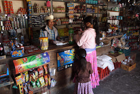
A Tarahumara Indian woman shops in a local tienda in the Copper Canyon region.........
..... and then walks home beneath these strange and colorful ash flow tuffs that dominate the landscape in this region. Copper Canyon is cut into these relatively young (25 million years old) volcanic rocks.
Here are a few more scenes of the Tarahumara.
And the hotel on the rim of the canyon where we stayed for two nights.
Adventure and foreign travel, philosophical and scientific musings, geology and landscapes, photography and earthly explorations.
Sunday, November 09, 2008
Tuesday, October 14, 2008
"Ancient Landscapes of the Colorado Plateau" makes its debut at GSA in Houston!
My new book, "Ancient Landscapes of the Colorado Plateau" made its formal debut at the Annual Meeting of the Geological Society of America. This professional conference was held for five days in Houston, Texas. The book is co-authored by one of my former professors, Dr. Ron Blakey. It was such a pleasure to work with Ron and help him get his maps published in book form! The book so far has been very well received. You can order a signed copy at the Grand Canyon Association bookstore. Note however that most of the copies are still on a boat from Hong Kong - we had 500 copies air freighted out for this conference.
I took in many of the professional talks. Some of the interesting topic sessions I attended included: "Return to the Moon: A New Era of Lunar Exploration." One of the talks in this session was given by Harrison "Jack" Schmitt, the 12th man to walk on the moon. Many of the talks in this session tried to explain why we should return to the moon and why the south polar region is a good place to start (there are a few crater rims here that have eternal sunlight to fuel solar powered devices). I saw some great talks about mega-landslides, including some in the Grand Canyon that contain 30 billion cubic meters of material. There were educatrional talks about "Why Study Geology" by Eldridge Moores; "Abandonment of Unaweep Canyon, Colorado in the Last One Million Years" by Karl Karlstrom; and "The History and Influence of Religion on Geology", a topic I am quite interested in. A few young earth creationists were in attendance and the room they alloted to the session was filled to overflowing (I had to lay on the floor in the front of the room to get admitted!).
Helen and I then drove from Houston back to Arizona. We so enjoyed the ride across the Edwards Plateau where limestone road cuts revealed many interesting features. We drove through the town of Pecos and saw the recreated courtroom of Judge Roy Bean. The town has definitely seen better days.
In the yard just outside this recreated Justice of the Peace, there was a gravesite that had the most unusual and uniquely Texas epitaph: Robert Clay Allison - He Never Killed A Man That Did Not Need Killing." I just cracked up laughing for a long time reading this one. Texas is definitely different!
We eventually entered New Mexico ans saw a fantastic natural event - the evening exit of hundreds of thousands of bats from the natural entrance to Carlsbad Caverns. This is a photo of the cavern before the bats exited - they do not allow photos while they are in flight. This was so memorable. We ate Mexican food for every meal from San Antonio to Flagstaff! Heaven indeed.
Thursday, September 25, 2008
A Geological Raft Trip in the Grand Canyon
When in France they say ... taste the wine. When in Rome ... do not miss the food. And when in the Grand Canyon ... you simply must yield to the magic of deep time. Where the Colorado River has carved a mile deep gorge, 20 lucky souls were captivated by the pull of the great river in a sweet, moonlit canyon. On a geology charter trip organized by Jan Taylor and outfitted by Arizona Raft Adventures, I was along as a honorary "reader of the rocks". Our group was wonderful! The guides were fantastic! And we all left the canyon imbued with the spirit of beauty and peace that permeates this blissful place.
Entering the Grand Canyon below Lees Ferry. Although the river cuts into the rock at only about eight feet per mile, the strata rise up at the same time at over 100 feet per mile. We are soon immersed in a great, rocky gorge.
One of our boats splashing in House Rock Rapid - big for sure but not scary and nothing that should deter a trip on the river in Grand Canyon.
Beautiful Redwall Cavern, a large eddy-carved depression in the Redwall Limestone.
A typical camp scene along the river. Here, our guide Rob Elliott is blowing a conch shell to announce that dinner is ready. Come and get it!!
This is the "classroom" and "office" where I get to live and work. The "book of geology" is open and people learn so quickly from it.
A calm morning on the river as our boats headed downstream towards Nankoweap Canyon. The weather was perfect on this trip.
The full moon setting as the sun rises on Vishnu Temple, September 16, 2008. Photo taken from Cardenas Camp.
An MNA archaeological dig near Unkar.
Sue and Jan get clean in Clear Creek.
A long exposure of the "horizontal waterfall" up in Clear Creek.
Tapeats Creek is one of my favorite side canyons! Here, a Cardinal Monkey flower sings in ecstasy as it drinks from these pure waters.
In the background you can see a classic angular unconformity. About 525 million year ago, beach sands (Tapeats Sandstone) were washed over an eroded edge of the Hakatai Shale (tilted red beds. In this way, an ancient island was buried in sand.
We hiked up Tapeats Creek to see Thunder River, where a spring issues forth from the base of the Redwall Limestone.
A beautiful rock garden in Matkatamiba Canyon.
This is what we had to do to get up to the rock garden. Toni and Mary showing good form as they "bridge" across the creek.
An unusual camp at a place called Upper Ledges. We got nice and cozy here as we slept on the rock ledges.
Hands across Havasu - we made many new friends along the way. The trip proved to be an excellent way to learn about earth history and we came away with a greater appreciation of the splendor and beauty of the Grand Canyon. Join me next year as I repeat this trip with Canyoneers, September 13 to 22, 2009.
Thursday, July 31, 2008
A Summertime Hike Into A Wilderness Canyon
During the week of July 21, I backpacked for four days into a wilderness canyon in southeast Utah. I was traveling with four of my best friends and we saw some pretty amazing things. Below are a few photos from the trip. Of course, photo's cannot capture the real beauty of a place but they can give a sense for the flavor of how life must have been for our Anasazi ancestors over 800 years ago. Enjoy the ride!
Wow - check out this huge alcove carved out of the sides of the canyon walls. Sites like this were ideal for habitation and rock art.
Here John is observing one of the best rock art panels I have ever seen in the whole southwest. The Anasazi used rock pigments mixed with organic substances to "fix" the images on the canyon walls. What they stand for we can only guess but to visit such a site is a remarkable experience.
These pictographs are perfectly preserved after 800 years. Whatever material was used to denote the head has weathered away leaving these ghostly, headless figures.
We moved to another of the seemingly endless alcoves. The scenery was surreal - a world unto itself and set within the outer world.
Here we found a fantastic ruined house. It had a split-level design and much of the roof was still intact. We were in awe.
The inhabitants had left their "signature" on the wall behind the house. It says, "I was here but you are now. Enjoy the ride".
Here's a view from above the house looking out to our camp across the way. It was wonderfully eerie to think that others had experienced this view over 800 years ago. What did they think? Did they have any idea that the earth is 25,000 miles in circumference?
The evidence was everywhere that these people left their home relatively quickly. Ancient corn cobs and pottery was everywhere. It means so much more when it is just left here in its rightful place.
I looked closely at the end of one of the roof beams. There in front of me was the evidence that someone had chopped down this tree with a stone axe - the scars were clearly visible. The center part of the wood had not been chopped, rather it looked like the people had pushed over the tree at the last moment to make the final break. On the other side of this log was the cork-filled hole where a dendrochronologist had made a determination for the exact year that the tree had been felled. Amazing.
Monday, June 30, 2008
I've Been Blogged!
I recently traveled on a GrandLuxe Rail journey giving lectures from Albuquerque to Grand Canyon. One of my fellow passengers, Ruth Mitchell, wrote about me on her blog, which you can find at: http://www.buyoutsidethebox.com/blog/ You can follow along with Ruth on the rest of her journey to Yellowstone. Here is what she shared about the Grand Canyon experience:
SATURDAY, JUNE 28, 2008
Day 3 Grand Rail Luxe Journey - Grand Canyon
It's been a wonderful day. We drove right up the edge of the Grand Canyon in the train, and took a tour with Wayne Ranney, a geologist who had been traveling with us and lecturing since we left Albuquerque. He is very knowledgeable, so it was a real treat to tour some of the highlights of the South Rim with him. We purchased his book, Carving Grand Canyon, and I look forward to reading it as he was such a delightful tour guide.
Sunday, June 15, 2008
Green Green Coastal Alaska!
It's been a few years since I visited southeast Alaska and I had almost forgotten just how green it is! This was a trip on the Lindblad/National Geographic Sea Lion, one of the ships I used to work on. I was lecturing as a Study Leader for Smithsonian Journeys. There were 23 wonderful and gracious Smithsonian travelers but the entire ship manifest listed 54 passengers. It was great to come back to this part of the world.
Our first stop was at the Eagle Recovery Center in Sitka, where injured eagles are rehabilitated for release into the wild
A look at one of the twelve totem poles at Sitka National Historic Park
Sunset at 10:30 PM near the Pacific Ocean entrance to the Sitka area
The beauty of George Island, another section of southeast Alaska very close to the open waters of the Pacific Ocean
Mossy tree branches. Everything is so green!
We saw many brown bears on this trip. Their populations seem to be doing quite well here.
A colorful garage with fishing gear in Petersburg
Reflections in the harbor at Petersburg. Sons of Norway Hall
Trails in southeast Alaska are built of planks and are quite pleasant to walk on
The Marguerite Glacier in Glacier Bay National Park!
After entering the Endicott Arm, we began seeing blue icebergs!
In the not too distant past, this U-shaped valley contained a glacier
This is the Dawes Glacier in Endicott Arm
We saw a calving of the glacier and here you can see the big splash from the ice fall. The height of the ice is almost 180 feet!
Here's a picture of one of our zodiacs cruising in the icebergs
And a look at the Sea Lion in Endicott Arm
In Juneau, the capital of Alaska, we arrived at the end of our trip during the famous "Celebration", when the Native people parade downtown. This man was way into it!
And a close-up of his face
Our first stop was at the Eagle Recovery Center in Sitka, where injured eagles are rehabilitated for release into the wild
A look at one of the twelve totem poles at Sitka National Historic Park
Sunset at 10:30 PM near the Pacific Ocean entrance to the Sitka area
The beauty of George Island, another section of southeast Alaska very close to the open waters of the Pacific Ocean
Mossy tree branches. Everything is so green!
We saw many brown bears on this trip. Their populations seem to be doing quite well here.
A colorful garage with fishing gear in Petersburg
Reflections in the harbor at Petersburg. Sons of Norway Hall
Trails in southeast Alaska are built of planks and are quite pleasant to walk on
The Marguerite Glacier in Glacier Bay National Park!
After entering the Endicott Arm, we began seeing blue icebergs!
In the not too distant past, this U-shaped valley contained a glacier
This is the Dawes Glacier in Endicott Arm
We saw a calving of the glacier and here you can see the big splash from the ice fall. The height of the ice is almost 180 feet!
Here's a picture of one of our zodiacs cruising in the icebergs
And a look at the Sea Lion in Endicott Arm
In Juneau, the capital of Alaska, we arrived at the end of our trip during the famous "Celebration", when the Native people parade downtown. This man was way into it!
And a close-up of his face