Tuesday, May 16, 2017

Hiking the Carbon Canyon/Lava Chuar Route in Grand Canyon

Been on many trips and writing from Waikiki where my sister will be married on Wednesday. However, here is a second installment from my first river trip in Grand Canyon in April of this year.

One of the most well-known geology side hikes on a Colorado River trip in Grand Canyon is the Carbon Canyon/Lava Chuar Route, beginning at River Mile 63. This loop hike ascends the Carbon Creek drainage about one and a quarter miles to the intersection of the Butte Fault, then follows the fault for another one and half miles before descending back to the river in Lava Chuar Canyon for the final one and a quarter miles. There is a fantastic scenery (which is to say - geology) along every part of this loop.

Interesting boulder of Tapeats Sandstone with tafoni texture in the Carbon  Creek drainage. There are a dozen or more of these here.

Iron concretions within the Dox Sandstone are always a curiosity begging an explanation. See this science article for a treatment of concretion formation.

Gigantic rock failure in Carbon Creek Canyon that necessitates a short but steep climb around it.

Jim and Billy resting after the climb on natural but well-positioned rock slab chairs.

Close-up of the Tapeats Sandstone showing its arkosic texture. The feldspar grains (pink) were derived from the Zoroaster Granite. But in this area of the canyon, the Tapeats rests entirely upon younger sedimentary rock units, so the feldspars were brought here from rocks not yet exposed in this part of the canyon.

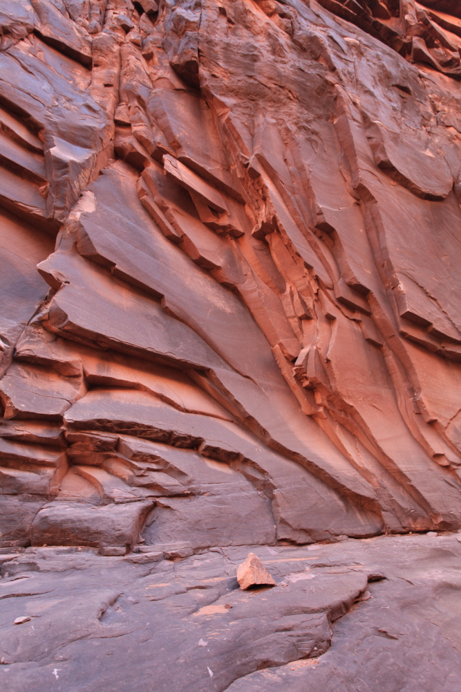
Once on top of the giant rockfall, the creek is confined in a slot canyon within the Tapeats.

Narrow slot canyon along Carbon Creek.

And then, the canyon opens up at the site of, and along the trace of the Butte Fault. For an aerial view of the Butte Fault see this link.

More flowers, this one is the Indigo bush.

Full blooming brittle bush.

A small drainage built this delta fan along the trail. This is a small scale example of how the rapids form on the Colorado River, when side canyons deliver debris that partially constricts the river channel.

View of the Chuar Group rocks in eastern Grand Canyon. This is the only locale where these rocks are found in the Grand Canyon and at 790 to 740 Ma, they are some of the few rocks from this age anywhere on planet Earth.

Finally, after entering Lava Chuar Canyon on the way back to the Colorado River, the route passes by some great exposures of the Dox Sandstone, part of the Unkar group and about 1,100 Ma.

These well-preserved ripple marks were seen and are part of the Dox Sandstone.

I will be headed back down the river this Friday for my third trip of the year and will post more by the end of the month.

Monday, May 01, 2017

Spring Wildflowers and Rocks in Grand Canyon

I recently completed an 11-day Hiking and Geology Special Rafting Trip in Grand Canyon with Colorado River and Trails Expeditions. The wildflowers this season are excellent. We did some great hikes in perfect conditions - 80 degree days and 50 degree nights.

Our first hike was up inside North Canyon, famous to geologists for it exfoliated sandstone surfaces.

At the reflecting pool in the back of North Canyon.

Note how the exfoliation planes mimic the shape of the open space in the canyon. As the canyon becomes progressively opened through this massive sandstone (massive meaning that it lacks significant bedding features or fractures and so behaves as a coherent substance), the sandstone in the walls "pops out" parallel to the shape of the open space. On the walls, the exfoliated planes are vertical but they turn to horizontal on the canyon floor. It makes for striking forms.

Enjoying the solitude and stillness in a Grand Canyon tributary.

Dan enjoys looking at a conglomerate-filled channel that was cut into the underlying sandstone. Such channels are not uncommon in the Supai Group rocks. This happened in the Pennsylvanian Period, some 300 Ma.

Huge, cross-bedded sets of sandstone in there Supai Group in North Canyon. The cross-beds are very planar and might suggest a dune blowing across the floodplain.

We saw two Chuckwallas on the way back to the boats. I love the Latin name for this species, (Sauromalus obesus), the "Big bad fat lizard."

The second one was this little juvenile with its distinctive banded tail. Chuckwallas are strictly herbivorous.

The Marble Canyon section of Grand Canyon has wonderful springs that issue from the Redwall Limestone. Here trip participants observe a travertine encrusted spring on the wall of the canyon. Maidenhair ferns (Adiantum capillus-veneris) and Golden columbines (Aquilegia chrysantha) are often growing at these sites.

Inside Redbud Alcove at River Mile 39.

Slopes covered in yellow brittlebush (Encelia farinosa) downstream from the Eminence Break at River Mile 44.

The Sedesrt globe mallow (Sphaeralcea ambigua) was just beginning to bloom.

Desert fleabane (Erigeron divergens) was found up in Saddle Canyon at River Mile 46.

A typical day on the boats below Nankoweap Canyon. Both oar-powered trips and motor-powered trips have pluses and minuses. I used to strictly use oar-powered craft but have now switched to motor-powered. There are numerous reasons why and you'll just have to come on one of my trips to find out why.

Engelman hedgehog cactus (Echinocereous engelmanni) at the confluence of the Little and Big Colorado rivers.

Imagine 10,000 people a day coming down from the point on the skyline in a tramway. No way!

Part 2 to follow later in the week.