I just completed my 7-day raft trip in the Grand Canyon and am pleased to share some photographs and stories about the trip. This posting is
not meant to be a comprehensive account of the trip, as there are too many things that happen on a trip like this. Rather, I like to pick a few choice stops and write at length about them. If you would like to read about other aspects from previous trips, scroll down on the right hand side of this page to
My Blog Archive. The months to peruse are August and September, 2011; September, 2010, September, 2009, and September, 2008.
This trip included nine members of the
Arizona Hydrological Society, as well as eighteen other geology enthusiasts. Some of these eighteen had no idea that geology could be so interesting but a place like the Grand Canyon makes geology fun and it comes easy to anyone with a little effort. (My next geology class at Grand Canyon will be a 3-day Rim-based classroom and short hikes adventure called "Geology on the Edge", offered by the Grand Canyon Field Institute. Check out the details
at this link and click the "On The Edge" button.
I hope you enjoy the virtual ride on this years 7-day Grand Canyon rafting trip!
Day 1
My geology-themed rafting trips are known for their short hikes to interesting places. Here, after traveling only 200 meters on the river, we stopped for a hike to an overlook along the Colorado River. The Vermilion Cliffs loom above the river in the right background. The photographer is standing on the Shinarump Conglomerate Member of the Chinle Fm.
Within the Shinarump Member are numerous and large petrified logs. This one has an oxidized red "halo" around it. Much of the Cold War uranium for bombs was obtained from such oxidized sources, which are known as "
roll front deposits".
The old Mormon dugway can be seen running through talus that lies on top of the Moenkopi Fm.
Much of the river in the canyon is calm water. The Colorado is known as a pool and drop river with long stretches of pools interrupted by steep rapids.
Day 2
Entering the Redwall Limestone section of Marble Canyon. John Wesley Powell named it Marble after the polished limestone found next to the river.
Since my last trip, a new fan of debris has developed into the river channel near river mile 30. a huge thunderstorm last fall brought this material down the side canyon.
Vasey's Paradise is a wonderful spring that issues from a cliff of Redwall Limestone. It is located near river mile 32.
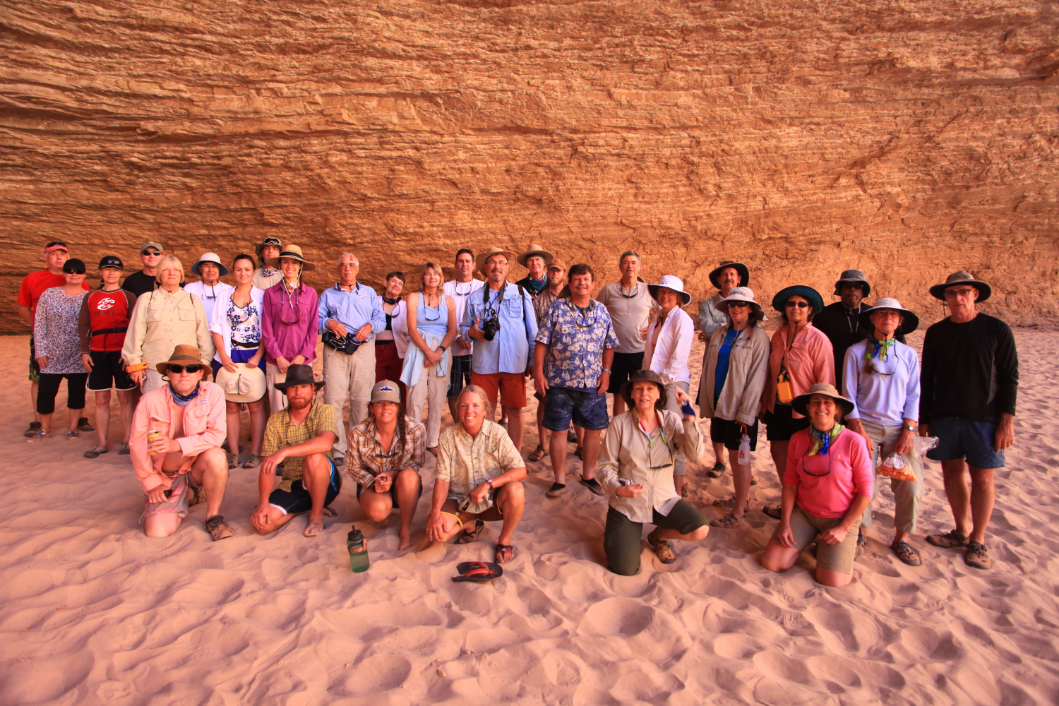
Here is a group photo shot inside Redwall Cavern. We had a very congenial group that laughed and played and learned the whole way!
Hiking a short way up to the "rapids" on the Little Colorado River (river mile 61). The water originates 13 miles upstream from the confluence at Blue Springs, the largest spring in the state of Arizona. The color of the water comes from the way limestone is dissolved in the water as it comes through caves.
Riding the "rapids" with a life jacket. These travertine dams form when the spring water releases CO2 after exiting the spring. The water is quite warm.
The Little Colorado River in the bottom of the Grand Canyon
Scenic reflection on the Colorado River looking upstream from the Little Colorado River confluence, June 11, 2012.
... A Collared Lizard Interlude
This
collared lizard (Crotaphyyus collaris) used a lack of motion to "hide" from our group as we walked by it at the Little Colorado River.
They are fantastic reptiles that often run in a bipedal fashion across the desert floor
The lizard is resting on the Tapeats Sandstone
And allowed me to photograph it from every possible angle
Day 3
One of the best geology hikes on a Colorado River trip is up Carbon Creek Canyon at Mile 64. Here our group is negotiating a large boulder in the floor of the canyon.
One of the highlights of the trip is seeing the Butte Fault about one mile up in the canyon. Here the Tapeats Sandstone i upturned 90 degrees from its original horizontal position. The fault shows many periods of activity beginning in the Precambrian and last moving during the Laramide Orogeny about 70 million years ago. That is when these beds were upturned. Important to remember is that when these beds were faulted to this position, the rocks shown were at least still 2 miles in the subsurface, maybe more. Erosion of the Grand Canyon has exposed what was previously bent.
Hiking along a quiet stretch in the Grand Canyon
Day 4
Much farther down the river we stopped at Blacktail Canyon at river mile 121. Here is fantastic exposure of
The Great Unconformity.
View out of Blacktail, a narrow slot canyon
Close-up of The Great Unconformity with Vishnu Schist below and Tapeats Sandstone above. Quartz clasts rest right at the surface of the unconformity, which represents 1,200 million years of time. Note the small dendrtites that seem to emerge from the quartz clasts on their top side.
A small scale channel within the Tapeats Sandstone just above the unconformity. These channels were likely cut as the waves of the Tapeats Sea washed back across the surface.
View of lunch at the mouth of Blacktail Canyon with Conquistador Aisle stretching away three miles in the background
Our trip leader Carolyn shares a laugh on the river
Day 5
The group checking out Bronze Black's informative river map while traveling down the river.
You can order a copy of this map here.
Havasu Creek at river mile 157 is a lush oasis in the desert. This is the second largest spring in Arizona.
While making a comfort stop on the white sand beach, we observed this interesting trackway
I am guessing that this was made by a river otter or a muskrat
Interesting pictograph panel at Whitmore Wash, site of our 5th nights camp
Here is the impression of an interesting invertebrate trackway in the Bright Angel Shale near Whitmore Wash.
It looks like the medium is soft sand, yet this is a rock that has been hardened through 515 million years of earth history
Day 6
While on the river, we get the opportunity to "follow" certain sedimentary layers that change thickness and color along the length of the river. This is the so-called "rusty brown dolomite" a layer within the Bright Angel Shale that we first noticed way upstream near Elves Chasm. Here in western Grand Canyon it was much thicker that when fist observed.
The Black Ledge lava flow (black, center) filled the channel of the Colorado River for at least 86 miles when it was erupted some 500,000 thousand years ago
Day 7
Final morning on the boat, our group assembled for one last picture. Having a predetermined theme for the trip meant that everyone came to it with similar goals. This is really the only way to undertake a river trip of such length. It does not need to be geology, but earth history is a dominant theme encountered in the Grand Canyon.
Our fantastic crew! Paul, Tom, Carolyn and Amity. Thanks to Canyoneers for providing such hard working and freindly guides.