I just returned from a fabulous trip to Toroweap Overlook on the north side of the Grand Canyon. I was leading a charter group of folks who have been with me before on many excursions, backpacks and river trips in the southwest. This trip was coordinated through the Grand Canyon Field Institute, who I highly recommend for any of their educational classes at Grand Canyon.
The trip to Toroweap involved car camping and day hiking for four days and three nights. Have a look and learn some geology from this spectacular location.
The famous Toroweap Road - 61 miles long and a real tire shredder if you drive too fast. We escaped this trip without any - on my last trip out here with a film crew we had three! Those are the Toroweap Cliffs on the left hand side and they are on the up-thrown block of the Toroweap Fault. A giant side canyon to the Colorado River was carved along this fault but the Toroweap Valley here is infilled with lava and gravel some 3,000 feet thick! Yep, this is valley fill we're driving on here. There's the south side of the Grand Canyon in the distance.
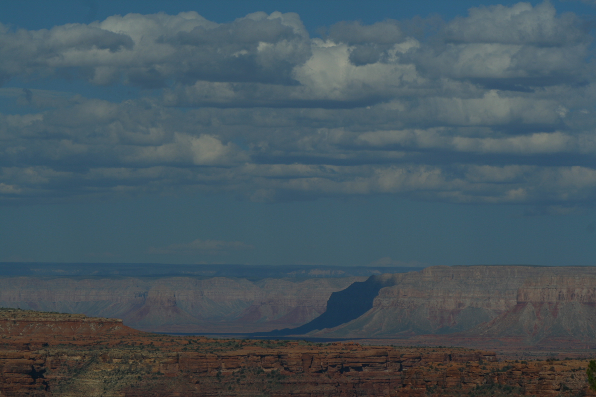
From our group camp site, we had a fantastic view to the east all the way to the Kaibab Plateau on the horizon. The smallish (looking) butte in the far sunlight is Mt. Sinyala, an erosional remnant that remains out on the Esplanade terrace.
On our first evening, we walked out to a viewpoint and watched the sunset. Across the river to the south, we spotted the first of many volcanic features here, a small cinder cone sitting on the Esplanade platform. Well, it looks small within the Grand Canyon but is likely 500 feet high.
The next morning, we took a walk to
the Overlook. Jim has no fear of heights whatsoever and was born to roam in these extreme canyonlands.
Looking downstream for the Overlook to numerous lava cascades that entered the Grand Canyon beginning about 700,000 years ago. You'll notice a prominent bench where the farthest cascade flattens out, then forms a cliff straight down to the river some 1,000 feet. This is the site of a former lava dam across the river and the inner cliff of basalt rock is the remnant of this dam. Perhaps as many of 13 lava dams once existed in the canyon and on at least 5 occasions, these dams failed catastrophically.
Excellent telephoto view of Lava Falls at river mile 179. We watched three groups go through the rapid and many of the boats ran left, signaling to us that the river flow was quite high this day.
We peered over the lip of rock beneath us and saw a large river boat circle around Vulcan's Anvil (the boat is 33 feet long and likely carries 15 people). This prominent block of basalt is interpreted as the eroded remains of a volcanic vent and if this is true, it makes Vulcan's Anvil one of the most unique settings ever for a volcano - right in the path of the Colorado River.
This is a cinder cone that lies perched above the junction of Prospect Canyon (left) and Grand Canyon (right). It appears that some of the cinder cone has already sloughed off into a widening Prospect drainage.
A close-up of the cross-bedding within the Esplanade Sandstone. Cross-bedding records the direction of currents that laid down the sediment and the direction the cross-beds dip (left to right here) show the direction that the current was moving. The Esplanade Sandstone was deposited in coastal rivers some 290 million years ago.
Our group stayed at the Overlook for 3 hours, watching river boats run the rapid and the sun run across the sky.
Looking upstream towards Cove Canyon at Toroweap Overlook. You can see the Cove Canyon fan that is spread across more than half of the Colorado River's channel here, pushing the river into a narrow rapid against the south wall of the canyon. Most Grand Canyon rapids form by debris dams that issue from side canyons into the river.
On day three we headed to a cinder cone located just one mile west of our camp - Vulcan's Throne! It sits right on the north lip of the canyon.
Vulcan's Throne as framed in a small valley on the Esplanade.
We parked the truck and began our 600 foot climb up the loose cinders.
Here is a view of another cinder cone - this one erupted against a slope of Hermit Formation (dark red rocks). Wow!
A valley filled with lava as seen from the slopes of Vulcan's Throne.
Once on the top of Vulcan's Throne, we had a marvelous view to the south up Prospect Valley. Note the partially eroded cinder cone discussed previously on the Esplanade surface, right side of the photo. Prospect Valley has been filled with lava but a new canyon has begun to etch its way back to the south (the prominent v-shape - center).
Group shot on top of Vulcan's Throne - from left Ed Hibbard, Al Astorga, Jim Randall, Jim Gruneisen, Howard Capito, and myself. (Steve Keagy not pictured but part of the trip). Toroweap Point in the background.
A graceful scene on the Esplanade. To read more about this landform
see my blog posting from a backpack on the Esplanade here.
Mt. Sinyala highlighted by the shadow of a cloud with the Kaibab Plateau on the far horizon near Swamp Point.
The weather was perfect for us and the clouds a treat.
Near our camp this old pinyon pine made for a wonderful subject at sunrise.
Shadows on a rock.
Driving out, we saw numerous snakes that were basking in the warm spring sun. Here Ed handles a bull snake.
The air quality was fantastic and on our way home we stopped at LeFevre Overlook on the Kaibab Plateau to view the Grand Staircase. The Vermilion, White, and Pink cliffs are clearly seen from this view. The Pink Cliffs are located very near Bryce Canyon. The Grand Staircase was named by Clarence Dutton in 1882 when he recognized that tilted strata had been stripped back by erosion to create one step on top of the other.


 I want to first of all thank ABPA for their recognition that science is a worthy topic deserving of its own category for an award in book publishing! In a time when science illiteracy runs rampant in our society, this is welcome news. Second, thanks to the judges for selecting "Sedona Through Time". It is self published so there was a significant financial and emotional commitment to see the project through. Third, thanks to my designer, Bronze Black of Flagstaff, who made the book so attractive and scientifically interesting. And lastly (but not leastly), thank you to my wife Helen, who encouraged me to keep this book in print, even when I thought it should just quietly disappear.