Monday, January 31, 2011

A Look at the Marcus Landslide in the McDowell Mountains of Arizona

For those aware of the special appeal in "seeing" long-gone events and the power of geologic observation in resurrecting such events, the Marcus landslide is a truly wonderful story. Imagine being a young geology student out on a spring field trip with your professors and other researchers. The day drags on as a few of the "big-wigs" co-opt an otherwise valued discussion, endlessly debating some arcane or miniscule detail. Predictably, you wander off away from the group with your best friend and ultimately stop to enjoy lunch.

Image courtesy of AZGS
With the wide expanse of the Sonoran Desert as your backdrop, you suddenly look up and notice an unusual and  vibrant concentration of golden brittlebush, back lit perfectly on the slopes of the McDowell Mountains outside Scottsdale, Arizona. Other parts of the range do not have this density of flowers and something appears unusual. You begin to also notice clusters of large granite boulders that seem to trend up the slope towards the colorful brittlebush. A lively exchange of ideas ensues and soon the light clicks on inside both of you - you have just detected the initial evidence for a giant Ice Age landslide that occurred here. No one else has ever seen this before!

Such is a description of how Brian Gootee and John Douglass discovered the Marcus landslide in 2002. (The feature was named in honor of the late
Melvin Marcus Professor of Geography at ASU). Gootee (now with the Arizona Geological Survey) and Douglass (now a professor at Paradise Valley Community College) completed subsequent research on the evidence left by this humongous slope failure. Admittedly subtle at first, the evidence is convincing that something big happened here about 500,000 years ago.
Aerial view of the Marcus landslide (AZGS)
View of the east side of the McDowell Mts. (AZGS)
Digital elevation image of the slide (AZGS)


I was fortunate to accompany my good friend Brian Gootee on a field trip to the Marcus landslide in January of this year. Accompanying us were his wife and duaghter, Rachel and Zoe, and my wife, Helen. Below are some of the photos I took on this glorious winter's day in the desert.

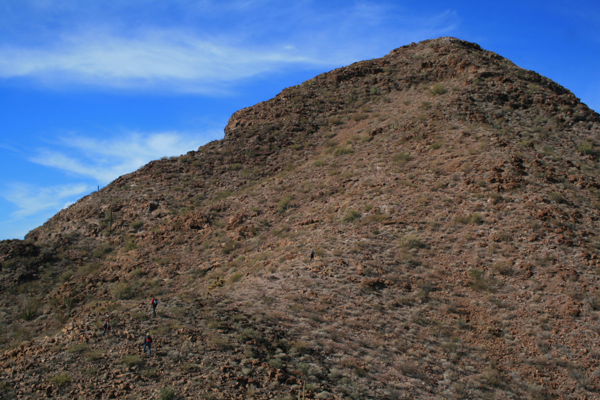
This is the east side of the McDowell Mountains looking south. Fortunately, this patch of desert is protected by the City of Scottsdale and Maricopa County in two nature preserves. The city and county are working closely with Brian Gootee to develop an interpretive trail to the slide.

A closer look to the south reveals a famous Arizona landmark in the Superstition Mountains - Weavers Needle. According to legend, the Lost Dutchman's gold mine was located within sight of this feature, meaning that the treasure could lie among the boulders in this slide. However, most of the people who believe in this legend scratch and scour the Superstition area.

As we hiked to the south we began to see the slope of the collapsed debris pile. You can see it in the middle distance between the sunlit foreground and the shaded slope of the mountain range.

Helen listens to Brian as he gives an excellent description of the features present and the sequence of observations that led him and colleague John Douglass to the conclusion that a giant slide mass is present here.

These are some of the granite boulders that are located on the north levee of the slide. This material likely originated high up on the slopes of the McDowell Mountain in a rock failure that was activated along joints (fractures) in the granite. It was then entrained with other smaller grained components into a debris flow that traveled almost one mile in length and 1/3 of a mile in width.

Detailed mapping has shown that the tilted boulder (above) is part of the slide material, but the granite it rests on is in place and not part of the slide. The evidence will be shown below.

Looking southeast across the Marcus landslide towards the Superstition Mountains.

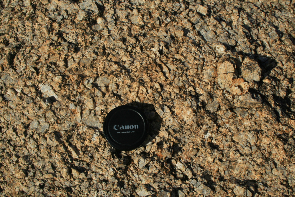
Here is a close-up (with lens cap for scale) of the clay and sand size material that makes up the matrix of the slide mass. As it came down the slope of the McDowell's, at an estimated speed of 16 to 44 miles per hour, the huge boulders would have been "cushioned" by this fine material.

Here is a view of the eastern terminus of the slide. Note that the boulders are not found farther out in the valley and outboard of the slide front. One of the boulders at this location is where Gootee and Douglass shared lunch on a field trip in the spring of 2002 and first pondered the possibility of a huge slide here. And if you are still wondering what the heck "an unusual concentration of brittlebush flowers" had to do with their discovery, note that the scar left on the side of the mountain front from the slide left the perfect substrate for the enhanced growth of brittlebush. They just happened to be in the right place at the right time of day and year!
 
Here is a close-up of the mega-crystic granite that forms the backbone of the McDowell Mountains and was caught up in the Marcus landslide. The quartz crystals are quite durable chemically but the feldspars weather more rapidly and certainly helped to facilitate the slide. Remember, this all happened just prior to 500,000 years ago (a date based on rock varnish micro-laminations) during the Ice Age, when Arizona was much wetter and cooler. These conditions certainly played a big role in the development of the slide.

How did Gootee and Douglass determine what granite was involved in the slide and what granite remained in place as bedrock. Look closely at the granite above and notice that the upper boulder has no joints in it, while the lower granite has at least three joints running through it. As the granite came down the slope catastrophically, it would have broken into its constituent pieces along joints. So the material arrived here already "chopped up". The lower granite wasn't involved in the slide and so still shows its obvious jointed nature.

A nice view of the slide front to the south - it is highlighted by the shade of the late afternoon sun. The timing of my visit did not allow for me to take pictures of the pocket or headwall area of the slide up in the mountains - it was looking right into the late afternoon sun.

A zoom view of the immense fountain in Fountain Hills, which can be seen during the first 15 minutes of every hour.

Please read Brian Gootee's official description of the Marcus landslide here on the AZGS official web site. You can also go on a virtual field trip to the slide on John Douglass' web site here. I can highly recommend both sites to learn more about this fascinating discovery.

If you would like to visit the Marcus landslide be aware that there are no signs yet, nor official trails to it. Use your ingenuity to find the trails on the east side of the McDowell Mountains that approach Tom's Thumb. Walk south from there and keep your eyes open for a train of debris that looks anomalously strange.

Tuesday, January 18, 2011

Amazing Photo's and Video of the April 4, 2010 Earthquake Near Mexicali

You've likely heard (and perhaps forgot) of the 7.2 magnitude earthquake on April 4, 2010 that occurred near Mexicali, Baja California. Recently, a friend forwarded some amazing photo's that were taken just as the rupture occurred. The oft-forwarded e-mail stated that the photos were taken by a California Highway Patrol officer, but these were clearly taken within Mexico by someone else. Lee Allison, colleague and Arizona State Geologist reports that they were taken by Danny Ashcraft.

The first set of photo's show the usual result of an earthquake - offsets and damage done to roads and bridges. But be sure to scroll all of the photos down to the end and see how a mountain range responds to the earth shaking. Amazing! You can also view a video clip of the earthquake, taken by the security camera at the Crown Plaza Hotel in Mexicali, here (sorry about the pre-video ad). 

*** Added note: Chris Rowan, author of the blog Highly Allochthonous, made me aware of this YouTube video of the rising dust plumes on the Sierra Mayor. Check it out here. *** 


The damage visible in this road appears to show some aspect of vertical offset to it (see the dirt portion adjacent to the road on the left). Most of the faults associated with the San Andreas system have lateral offsets but oblique offsets - those that combine vertical and horizontal displacement) can also occur.


In spite of the quake, folks appear to be having a great time seeing the results of our earth in motion.


Here is a bridge that obviously shows that the photos were taken in Mexico - I crossed this bridge just a few weeks ago on my trip to Sonora. It makes me wonder, who makes up these stories in the many e-mails that are forwarded to us? Taken by a CHP officer - jeez!


If you look at the white line in the road that was offset by the quake (near the funny man in the fault trough), you'll notice that it contains both a vertical offset and a horizontal offset. Note that the horizontal offset is left-lateral - that is if you stand and look across the fault, the other side was moved to the left. The San Andreas is typically a right lateral fault but smaller subsidiary faults can accommodate spatial motions with different senses of offset.


A badly damaged section of road that looks as if it was shaking quite violently during the 45 seconds of motion. But the real interesting photos begin now......


This is the Sierra Mayor looking west from the Mexicali Valley. The epicenter of the quake is located somewhere in this range.


The shaking of the earth caused huge dust storms to emerge from the rocks in the mountain range.
 
It must have been quite a series of sensations to behold - first to feel the whole ground shake beneath your feet, then see large volumes of dust rise out of the nearby mountains. Earthquakes are attention grabbing events that remind us that the earth is alive! These lucky folks were able to experience this one without the fear of something toppling over and injuring (or worse, killing) them. An ideal spot to be on this Easter Sunday.

A final look at the dust plumes from the Sierra Mayor earthquake last Easter Sunday. Studies of the San Andreas Fault by scientists at the US Geological Survey suggest that there is a 95% chance that a large rupture will occur on the system within the next 20 to 30 years. People who live in this area should remind themselves every day that they live next to one of the planets most seismic areas and prepare as best they can for a large shake.

Thanks to Glenn Rink of Flagstaff, Arizona for sending these photos along. 


Here are some resources of the Easter Sunday quake and a well written summary that were originally posted as links on this blog but were re-uploaded  by myself as photos on January 27, 2015. The USGS no longer maintains those links.


Wednesday, January 12, 2011

A Short Trip to Sonora Looking for Warmth

 Winter in the Western US has been downright brutal for us non-skiers and sun seekers who normally expect cool, clear days in the American Southwest. But extremely cold temperatures, numerous snow storms and a large number of cloudy gray days have made this a winter to forget. So I took the opportunity to head to Mexico to see if I could find the sun. My lovely wife, Helen, encouraged me to go knowing that she would have one happy boy upon his return. Here are a few pictures.

I traveled to the Gulf coast of Sonora and the little hamlet of Puerto Lobos. Near there we found a volcanic remnant that looked ripe for hiking to. Here we are wandering through the senita cactus towards the top.


Ocotillos still had a few red flowers from the October rains and the sky finally turned blue.

Can you spot the three hikers? (two in the lower left of the photo and the other in the center)

Elson stands on top of "El Diente de Tiburon" (the shark's tooth) with Puerto Lobos visible in the back.

Here is a closer look at the little fishing village.

And closer still with the lighthouse clearly visible here.

From the top of El Diente looking south along the Sonoran coast of the Gulf of California. This is very wild country and was the last part of the entire coastline to receive a highway in only the last year.

A group shot from atop the shark's tooth.

Elsewhere to the southeast are isolated ranges of uplifted granite. There are likely bighorn sheep in such ranges that hardly ever see people.

A senita cactus fell victim to the recent drought atop el diente. Puerto Lobos in the background.

This is a typical Sonoran winter day! Cactus, blue sky and wispy cirrus clouds splayed by the winds.

This is what we live for! Shimmering skies and not a breath of moisture.

Elson and Cindy have a rustic but comfortable abode in Lobos that would make any desert rat feel at home. We played cards at night and hiked in the day.

Sunset on the veranda, January 6, 2011.

My stay was too short and there is much more to explore. I will be back. 

A Lobos sunset.

On January 7 I left Lobos and headed north and west to Alta California. A new coastal highway was opened in the last year and I decided to take it. After driving 120 miles to Puerto PeƱasco (Rocy Pt.) I turned on Highway 003 towards San Luis. This route passes through the Pinacate Bioreserve and there were some great interpretive signs.


The signs are state of the art and bilingual.


The geology interpretation was quite good. This one explains the 2 million year history of the Pinacate Volcanic Field. Cerro Pinacate can be seen in the distance.

After passing through the volcanic rocks, the new highway skirts the north edge of the gulf coast. This was formerly quite inaccessible country due to the aridity. In this photo you can see Colorado River sediments in the foreground with the mountains of Baja California in the background. 

This last photo shows the main street in El Golfo de Santa Clara, a small fishing village with a quaint charm. The tacos were muy excelente!