I am about to embark on a six-day field trip to the Henry Mountains in Utah. As always, it was my students who chose the topic for this semester's class. Most people I talk to have just looked at the Henry's from afar. That is certainly my case. But we will be spending some quality time here using the BLM's Starr Springs campground as a base. I hope to spend a day exploring the Dirty Devil River canyon to the east, one day looking around the south side of Mt. Hillers, where the sedimentary rocks have been upturned in the emplacement of the laccolith, one day exploring the southern Waterpocket Fold, and a free day to go somewhere else.
Check back here in the first week of May for some photo's and the blog. Needless to say, this is a primitive camp with no option to send photo's from the field.
Friday, April 24, 2009
Friday, April 10, 2009
Exploring Canyonlands and Arches with the Museum of Northern Arizona
The Museum of Northern Arizona offers its members a travel and education program called "Ventures". Educational backpacks, house boat trips on the Powell Reservoir, and hotel-based excursions to Grand Staircase/Escalante and the Canyonlands are some of the itineraries offered. The latter near Moab, Utah is where I have been recently exploring some geologic wonders with some of our Museum members.

Here is the entrance sign at the new Visitor Center in Arches National Park. This modern facility was one of the first to use Ron Blakey's paleogeographic maps in their geology display. Their bookstore sells "Ancient Landscapes of the Colorado Plateau" (Blakey and Ranney, 2008) and visitors can now take these informative maps home with them to study at their leisure.

Wow - check out the faulting displayed across from the Visitor Center on Highway 191! The strata belong to the Pennsylvanian Elephant Canyon Fm. and were offset on a branch of the Moab Fault when the Spanish Valley salt dome deformed the rocks.

Our group hiked up to the iconic symbol of Arches National Park, Delicate Arch. It has been carved into the Entrada Sandstone and is unusual in that this small remnant of a fin is almost entirely opened as an arch. The chances that this could occur, let alone be preserved for even a short amount of time, are astronomically small. Which may prove to the non-curious that there must be a God, but to most others simply means that where there is erosion there is form, color, and beauty!

I like the "non-arch" sections of this park as well. The uplift of the salt domes has elevated the land such that the views are long and wide. The uplift raised rocks to elevations where they have been attacked by gravity, leaving many pinnacles and spires. The La Sal Mountains provide a truly stunning backdrop. I can think of no other combination - snowy mountains framed by red strata - that says "the American West."
We felt like getting close to the La Sals and so drove up on the La Sal Mountain Loop Road. This is a close-up view of the La Sals, a laccolith intrusion that is about 25 Ma (million years old). The sedimentary veneer that once capped these rocks is since eroded off.

As we drove off of the mountain's north flank, we were treated to a great view of the Castle Valley along the Colorado River.

For me, a visit to this part of the Plateau is incomplete without a stop at the Fisher Towers. The number of movies filmed here are testament to their great beauty but most people don't realize that a phenomenal geologic story is contained in the rocks here as well. It involves ancient mountains that no one ever saw, yet the debris washed out of those mountains remains.....

..... Look at the boulder on the left. Do you see the clasts of schist and gneiss in the sandstone? That is the evidence that a range of mountains, the Ancestral Rockies, once stood east of here about 285 Ma. As the ARM's eroded, material was shed to the west and became incorporated as the Culter Group. When you follow this formation to the east the clasts get bigger, and to the west they get smaller, giving the tell-tale signs of what direction the sediment was being shed.

Ron Blakey's paleogeographic map for the Cutler Group, about 285 Ma. Notice the Ancestral Rockies in southwest Colorado. At the foot of the mountains just inside the Utah state line is where the Fisher Towers are located. Who says there are no time machines?

Just when I begin to feel like there might be too much "red rock fatigue", I turn the van into a small parking lot and we hike up into a watery wonderland called Negro Bill Canyon. You can imagine the older, less sensitive name (some Moab locals have taken political correctness to a new level and refer to this gem of a stream as "African-American William Canyon"). No matter what you call it, the canyon is beautiful and Bill or William had good taste in locating a home. There's nothing like water in the desert.

Two miles up at the head of a side canyon is a source of water coming out of a crack in the sandstone. The water emerges from near the contact of the Navajo Sandstone (the aquifer) and the Kayenta Fm. (the aquaclude or aquatard). Magic!
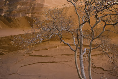
A hackberry tree against the cliff. Is there anything more special that being in places of such beauty?

Morning Glory Arch

The Island in the Sky District of Canyonlands is a place where you can get a sweeping view of everything. Here, Ron Hansen takes in the view.

Looking south towards the Abajo laccolith with the Needles District of Canyonlands in the middle distance. The Needles are part of the Cedar Mesa Sandstone which is the distal extension of the Cutler Group. This part of the region was far enough away from the Ancestral Rocky Mountains that only sand was preserved here. No cobbles of schist or gneiss made it this far out onto the ancient floodplain.

At the Green River Overlook we took in a view of the Turk's Head, a rocky eminence that resembled a turban to some old explorer. The Green River flows nearby. The Turk's head is capped with the White Rim Sandstone.

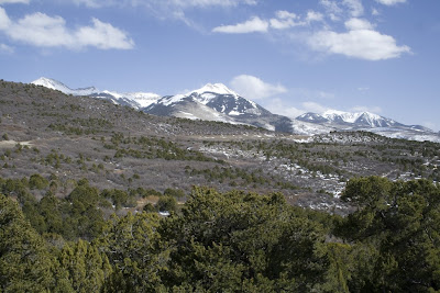
Looking west, we saw the Orange Cliffs and the Henry Mountain laccolith rising behind them. Why aren't the Orange Cliffs part of Canyonlands National Park?

We did a couple of short hikes around Upheaval Dome, an aptly named oddity in otherwise flat strata. I pulled out three different brochures from the park that reveal the changing interpretations made for this unusual feature. In the 1981 edition, a salt dome interpretation was presented. In a 1993 edition, the salt dome theory competed with an interpretation that this could be a meteorite impact structure. The newest edition of the trail guide lists meteorite impact structure first and salt dome second. An evolving view that highlights the scientific method. That is the beauty of science, it is self correcting and at times can be wrong. But always, science tends towards a more refined truth.

Look at the scalloped heads of these two canyons into the White Rim. There is no indication that the canyons were carved by water running from above. Rather, they seem to be formed from below, meaning that groundwater sapping has undercut the White Rim Sandstone, which causes headward dissection in the upstream direction. The canyons are created from the bottom up and not the top down. Come on a trip with the Museum of Northern Arizona and see for yourself!

Here is the entrance sign at the new Visitor Center in Arches National Park. This modern facility was one of the first to use Ron Blakey's paleogeographic maps in their geology display. Their bookstore sells "Ancient Landscapes of the Colorado Plateau" (Blakey and Ranney, 2008) and visitors can now take these informative maps home with them to study at their leisure.

Wow - check out the faulting displayed across from the Visitor Center on Highway 191! The strata belong to the Pennsylvanian Elephant Canyon Fm. and were offset on a branch of the Moab Fault when the Spanish Valley salt dome deformed the rocks.

Our group hiked up to the iconic symbol of Arches National Park, Delicate Arch. It has been carved into the Entrada Sandstone and is unusual in that this small remnant of a fin is almost entirely opened as an arch. The chances that this could occur, let alone be preserved for even a short amount of time, are astronomically small. Which may prove to the non-curious that there must be a God, but to most others simply means that where there is erosion there is form, color, and beauty!

I like the "non-arch" sections of this park as well. The uplift of the salt domes has elevated the land such that the views are long and wide. The uplift raised rocks to elevations where they have been attacked by gravity, leaving many pinnacles and spires. The La Sal Mountains provide a truly stunning backdrop. I can think of no other combination - snowy mountains framed by red strata - that says "the American West."

We felt like getting close to the La Sals and so drove up on the La Sal Mountain Loop Road. This is a close-up view of the La Sals, a laccolith intrusion that is about 25 Ma (million years old). The sedimentary veneer that once capped these rocks is since eroded off.

As we drove off of the mountain's north flank, we were treated to a great view of the Castle Valley along the Colorado River.

For me, a visit to this part of the Plateau is incomplete without a stop at the Fisher Towers. The number of movies filmed here are testament to their great beauty but most people don't realize that a phenomenal geologic story is contained in the rocks here as well. It involves ancient mountains that no one ever saw, yet the debris washed out of those mountains remains.....

..... Look at the boulder on the left. Do you see the clasts of schist and gneiss in the sandstone? That is the evidence that a range of mountains, the Ancestral Rockies, once stood east of here about 285 Ma. As the ARM's eroded, material was shed to the west and became incorporated as the Culter Group. When you follow this formation to the east the clasts get bigger, and to the west they get smaller, giving the tell-tale signs of what direction the sediment was being shed.

Ron Blakey's paleogeographic map for the Cutler Group, about 285 Ma. Notice the Ancestral Rockies in southwest Colorado. At the foot of the mountains just inside the Utah state line is where the Fisher Towers are located. Who says there are no time machines?

Just when I begin to feel like there might be too much "red rock fatigue", I turn the van into a small parking lot and we hike up into a watery wonderland called Negro Bill Canyon. You can imagine the older, less sensitive name (some Moab locals have taken political correctness to a new level and refer to this gem of a stream as "African-American William Canyon"). No matter what you call it, the canyon is beautiful and Bill or William had good taste in locating a home. There's nothing like water in the desert.

Two miles up at the head of a side canyon is a source of water coming out of a crack in the sandstone. The water emerges from near the contact of the Navajo Sandstone (the aquifer) and the Kayenta Fm. (the aquaclude or aquatard). Magic!

A hackberry tree against the cliff. Is there anything more special that being in places of such beauty?

Morning Glory Arch

The Island in the Sky District of Canyonlands is a place where you can get a sweeping view of everything. Here, Ron Hansen takes in the view.

Looking south towards the Abajo laccolith with the Needles District of Canyonlands in the middle distance. The Needles are part of the Cedar Mesa Sandstone which is the distal extension of the Cutler Group. This part of the region was far enough away from the Ancestral Rocky Mountains that only sand was preserved here. No cobbles of schist or gneiss made it this far out onto the ancient floodplain.

At the Green River Overlook we took in a view of the Turk's Head, a rocky eminence that resembled a turban to some old explorer. The Green River flows nearby. The Turk's head is capped with the White Rim Sandstone.

Looking west, we saw the Orange Cliffs and the Henry Mountain laccolith rising behind them. Why aren't the Orange Cliffs part of Canyonlands National Park?

We did a couple of short hikes around Upheaval Dome, an aptly named oddity in otherwise flat strata. I pulled out three different brochures from the park that reveal the changing interpretations made for this unusual feature. In the 1981 edition, a salt dome interpretation was presented. In a 1993 edition, the salt dome theory competed with an interpretation that this could be a meteorite impact structure. The newest edition of the trail guide lists meteorite impact structure first and salt dome second. An evolving view that highlights the scientific method. That is the beauty of science, it is self correcting and at times can be wrong. But always, science tends towards a more refined truth.

Look at the scalloped heads of these two canyons into the White Rim. There is no indication that the canyons were carved by water running from above. Rather, they seem to be formed from below, meaning that groundwater sapping has undercut the White Rim Sandstone, which causes headward dissection in the upstream direction. The canyons are created from the bottom up and not the top down. Come on a trip with the Museum of Northern Arizona and see for yourself!
Wednesday, April 08, 2009
More Hiking the Grand Canyon with Kids!
After arriving at the bottom of the Grand Canyon we spent two days and two nights enjoying the scenery, the lemonade and beer and the geology. It was fantastic.

This is the entrance to the Phantom Ranch area. The mule rides end here after 10 long miles on the trail. The only difference between hiking to the bottom of the Grand Canyon and riding a mule to the bottom is which part of your body hurts at the end of the day!

Helen helps Jared and Cara with their Junior Ranger questions on the lawn in front of the canteen. Both of them excelled and were sworn in by Ranger Pat later on in the ranger station.

Here is a shot of our camp as Helen, Cara, and Jared prepare lunch. It is a beautiful campground near Phantom Ranch as many readers of this blog will know.

From the bottom of the canyon, one can look up 5,000 vertical feet and see the South Rim near Mather Point. Amazing to think that all those hundreds of people are up there looking into the canyon.
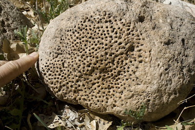
We found this cobble of Redwall Limestone near the entrance to the campground. You can easily see a fossil within it, which may belong to a sponge (Stromataporid) or a coral (Michelinia).

Here is a view of the calm waters of Bright Angel Creek. This is such a wonderful little stream - too cold to swim in this time of the year but at other times, it is a welcome respite from the heat. Although this creek is placid today, take a look at the next two photos for evidence of its prior fury.

A mass of boulders located on the delta of Bright Angel Creek near the Colorado River. This massive delta has pushed the river channel against the south wall of the inner gorge. How did these boulders get here.....?

... Don inspects the truncated edge of the delta deposit along the banks of the Colorado River. These boulders were entrained in a massive debris flow that roared down Bright Angel Canyon perhaps a few hundred thousand years ago. I have seen this deposit upstream where it is over 75 feet thick. This was a single flood event, caused by the catastrophic collapse of rock during wetter, Ice Age conditions. It moved down Bright Angel Canyon like a slurry of rock and mud.
As we left the Ranch, we looked back along the River Trail and said our goodbyes to Zoroaster Temple.

On day four, we left Indian Gardens and began the final 3,000 foot climb to the South Rim.

Here Ann looks at the trace of the Bright Angel Fault. The Toroweap Fm. is on the left (east) and has been down-thrown about 150 feet relative to the uplifted Coconino Sandstone on the right (west). When one turns around 180 degrees from this view....

... this is what you see. Two canyons carved along the line of the fault. Garden Canyon in the foreground and in the distance, Bright Angel Canyon back into the North Rim. The fault surface is clearly seen on the left side of the photo. A spectacular finish to a wonderful hike. Many thanks to Don, Ann, Cara, Jared, and Helen for being great trail mates!

This is the entrance to the Phantom Ranch area. The mule rides end here after 10 long miles on the trail. The only difference between hiking to the bottom of the Grand Canyon and riding a mule to the bottom is which part of your body hurts at the end of the day!

Helen helps Jared and Cara with their Junior Ranger questions on the lawn in front of the canteen. Both of them excelled and were sworn in by Ranger Pat later on in the ranger station.

Here is a shot of our camp as Helen, Cara, and Jared prepare lunch. It is a beautiful campground near Phantom Ranch as many readers of this blog will know.

From the bottom of the canyon, one can look up 5,000 vertical feet and see the South Rim near Mather Point. Amazing to think that all those hundreds of people are up there looking into the canyon.

We found this cobble of Redwall Limestone near the entrance to the campground. You can easily see a fossil within it, which may belong to a sponge (Stromataporid) or a coral (Michelinia).

Here is a view of the calm waters of Bright Angel Creek. This is such a wonderful little stream - too cold to swim in this time of the year but at other times, it is a welcome respite from the heat. Although this creek is placid today, take a look at the next two photos for evidence of its prior fury.

A mass of boulders located on the delta of Bright Angel Creek near the Colorado River. This massive delta has pushed the river channel against the south wall of the inner gorge. How did these boulders get here.....?

... Don inspects the truncated edge of the delta deposit along the banks of the Colorado River. These boulders were entrained in a massive debris flow that roared down Bright Angel Canyon perhaps a few hundred thousand years ago. I have seen this deposit upstream where it is over 75 feet thick. This was a single flood event, caused by the catastrophic collapse of rock during wetter, Ice Age conditions. It moved down Bright Angel Canyon like a slurry of rock and mud.

As we left the Ranch, we looked back along the River Trail and said our goodbyes to Zoroaster Temple.

On day four, we left Indian Gardens and began the final 3,000 foot climb to the South Rim.

Here Ann looks at the trace of the Bright Angel Fault. The Toroweap Fm. is on the left (east) and has been down-thrown about 150 feet relative to the uplifted Coconino Sandstone on the right (west). When one turns around 180 degrees from this view....

... this is what you see. Two canyons carved along the line of the fault. Garden Canyon in the foreground and in the distance, Bright Angel Canyon back into the North Rim. The fault surface is clearly seen on the left side of the photo. A spectacular finish to a wonderful hike. Many thanks to Don, Ann, Cara, Jared, and Helen for being great trail mates!
Tuesday, April 07, 2009
Hiking the Grand Canyon with Kids!
Over spring break Helen and I took some friends down to Phantom Ranch in the bottom of the Grand Canyon. Cara Webster is 14 and her brother Jared is 10. They carried their ow backpacks, thus relieving Daddy Don and Mommy Ann from having to carry everything for them. Everyone did great on this hike.

Here's a picture of our group as we started out on the South Kaibab Trail. It was a little cold to start out but we walked into increasingly warmer temperatures.

Windy Ridge on the trail. The day before, the wind was howling about 50 mph across this ridge. We were lucky to have missed that!

The upper strata of the South Rim. From top to bottom it is the Kaibab Limestone, Toroweap Fm., Coconino Sandstone, Hermit Fm., and Supai Group.

These are red and white switchbacks through the Redwall LImestone, about halfway down to the river.

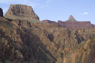
Our group hiking with Zoroaster Temple looming ahead across the Colorado River.

This was our view as we approached Panorama Point, about 5 miles down the trial. You can see the ribbon green of Bright Angel Creek and our camp was on the left hand side of it.

Ahh, the Colorado River. What a gem. Look at the sedimentary rocks in the upper part of the photo. They belong to the Grand Canyon Supergroup rocks.

A bighorn sheep ewe was just sitting on the trail as we approached the Phantom Ranch area.

Here's a picture of our group as we started out on the South Kaibab Trail. It was a little cold to start out but we walked into increasingly warmer temperatures.

Windy Ridge on the trail. The day before, the wind was howling about 50 mph across this ridge. We were lucky to have missed that!

The upper strata of the South Rim. From top to bottom it is the Kaibab Limestone, Toroweap Fm., Coconino Sandstone, Hermit Fm., and Supai Group.

These are red and white switchbacks through the Redwall LImestone, about halfway down to the river.

Our group hiking with Zoroaster Temple looming ahead across the Colorado River.

This was our view as we approached Panorama Point, about 5 miles down the trial. You can see the ribbon green of Bright Angel Creek and our camp was on the left hand side of it.

Ahh, the Colorado River. What a gem. Look at the sedimentary rocks in the upper part of the photo. They belong to the Grand Canyon Supergroup rocks.

A bighorn sheep ewe was just sitting on the trail as we approached the Phantom Ranch area.
Friday, April 03, 2009
20,000 Days!
Today, April 3, 2009, marks my 20,000 day here on planet Earth! I have been asked by some, "Why would anyone mark, let alone know, when such an milestone occurs"? Well, it's really easy to know how many days, weeks, months, hours, minutes and even seconds you have been alive with a web site I have used for at least two years. Here's the link: http://www.paulsadowski.com/birthday.asp. This wonderful site allows anyone to insert their birthday and birth year and then know many things about their age. Check it out.
Of course, as a geologist I am fascinated with time. It turns out that I am about 1.728 billion seconds old and so nearly as old in seconds as the Vishnu Schist is in years. That's a pretty amazing thought. My 500,000 hour is coming up quick so I'll be celebrating again! Here's all of the info as of 3:30 PM MST:
As of 4/3/2009 3:32:44 PM MST
You are 54 years old.
You are 657 months old.
You are 2,857 weeks old.
You are 20,000 days old.
You are 480,018 hours old.
You are 28,801,112 minutes old.
You are 1,728,066,764 seconds old.
It's a cold windy day in Flagstaff today but I am celebrating this momentous day.
Subscribe to:
Posts (Atom)